


Technical Parameter
|
Aircraft
|
|||
|
Weight(with propeller&battery) |
1209g |
Max range |
22 km |
|
Max Takeoff weight |
1999g |
Max angular velocity |
120/s |
|
Dimension |
457*558*108mm(Flod)) 230*130*108mm(Unflod) |
Max tiltAngle |
33° |
|
Wheelbase |
397mm |
Maxflight time |
38 min |
|
Maxtakeoff height |
7000 m |
Max hover time |
33 min |
|
Max ascent speed |
8 m/s |
Max wind resistance |
12m/s |
|
Max descent speed |
4m/s |
Positioningsystem |
GPS/GLONASS/Galileo/BDS |
|
Max horizontal flight speed |
20m/s |
Operating ambient tem |
-10℃~40℃ |
|
Image transmission distance |
15km |
Frequency band |
2.4GHz/5.8GHz/900MHz* |
|
PZT
|
|||
|
Stable system |
Triaxial stability |
Max control speed |
300°/s(Tilt) |
|
Controllable rotation range |
Pitch Angle:-90°to +30° Course:-90°至+90° |
Angular jitter |
±0.005° |
|
Infrared camera
|
|||
|
Video resolution |
640x512@25fps |
Accurate temperature measurement distance |
2-20米 |
|
Lens |
Visual Angle:H33°V26° Focus Distance:13mm |
Temperature range |
High-gain mode:-20°to+150° Low gain mode:0°to+550° |
|
Visible light camera
|
|||
|
Video resolution |
3840x2160P60/P50/P48/P30/P25/P24 2720x1528P60/P50/P48/P30/P25/P24 1920x1080P120/P60/P50/P48/P30/P25/P24 |
Max photo size |
8192*6144(4:3) 4096*3072(4:3) 3840x2160(16:9) |
|
Sensor |
1/1.28 in CMOS,50 megapixels |
Zoom |
4X |
|
Remote Controller
|
|||
|
Operating Frequency |
902-928MHz(FCC) 2.400-2.4835GHz 5.725-5.850GHz |
Endurance time |
2.5Hours(Max brightness) 4.5Hours (50%brightness) |
|
Signal Distance |
FCC:15km CE:8km7000 m |
Battery |
5800mAh |
|
Screen |
2048x153660fps |
Charging time |
90min |
|
Battery
|
|||
|
Capacity |
7100 mAh |
Charging time |
90min |

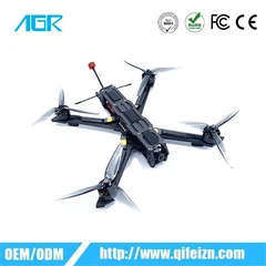
T3 quadcopter drone
Thermal imaging camera|Visible light camera|
Six directional binocular omnidirectional obstacle avoidance
Four rotor small unmanned aerial vehicle,supporting dual imaging of thermal and visible light,with flexible deployment capability,and supporting high-definition remote image transmission up to 15KM.The fuselage is equipped with 12 visual sensors,integrating 19 sets of sensors such as the main camera,ultrasound,IMU,etc.,to construct real-time 3D maps and plan paths.It not only perceives,but also achieves multi angle and all-round obstacle avoidance,easily crossing complex areas such as forests,mountains,and cities, and providing escort for flight missions
Functional Features
01
THERMALIMAGING CAMERA
Paired with a640*512 high-resolution infrared thermal imaging camera
02
VISIBLE LIGHT CAMERA
Support 50 million pixel visible light imaging,discover more details, assist in evidence collection,and achieve accurate judgment
03
15KM HIGH-DEFINITION REMOTE IMAGE TRANSMISSION
Supports transmission in three frequency bands of 2.4GHz/5.8GHz/
900MHz*,and can adaptively switch transmission frequency bands ac- cording to actual environments to ensure stable and smooth signal trans- mission,providing protection for shooting operations

Accessories (Optional)
product comparison bg model
Lorem ipsum dolor sit, amet consectetur adipisicing elit.
 |
 |

|
|||
|
Night navigation lights |
Megaphone |
Searchlight |
|||
|
size |
39*72*34 mm |
Size |
46*80*77 mm |
Size |
48.5*72*63 mm |
|
Scope of work |
5000 m |
Adjustable angle |
0°~45° |
Scope of work |
30m |
|
Luminous intensity |
Maximum 486cd;Average 290cd |
Maximum decibel |
120dB |
illumination |
Illuminance of 11lux @30 meters direct |
Hot Tags: thermal drone Unmanned Aerial Vehicle Search And Rescue, China, manufacturers, suppliers, factory, customized, wholesale, Rectangle Route Planning Agriculture Drone, drone agriculture seeding, Agriculture Drone Sprayer Machine, , Drone For Planting Seeds, drone sprayer for agriculture price